Land Registry Boundaries
Contents
Article Summary
There are only 2 legal definitions for a property boundary, i.e. a physical boundary as it would appear from an examination on site, and a legal boundary as would appear on an authorised map. A Land Registry Boundary is merely the red line edged by the Land Registry around the inside perimeter of the black boundary appearing on an Ordnance Survey Map. The Land Registry overlay the red edging on the Title Plan they create for each property. This allows a reasonably accurate illustration of the boundary positions.
First Registration
When your property is first registered with the Land Registry the Land Registry use the documents provided by your solicitors to prepare a Title Register and Title Plan. These documents contain the full address of the property and a plan to show its location and the extent of the gardens.
Creating the Land Registry Title Plan
In preparing the Title Plan the Land Registry examine their Index Map, which is based on the Ordnance Survey map at a high scale, as follows:
- Urban Areas: 1:1250
- Rural Areas: 1:2500
- Remote Rural: 1:5000 or 1:10000
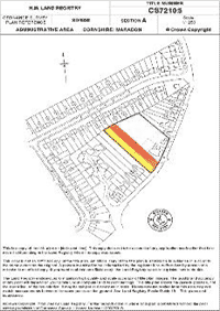
The Title Plan for your property is overlaid on the OS map, and red edging is inserted along the inside of the OS property borders, as in the sample below.

Land Registry Boundaries
It can be seen from the preceding paragraphs that the Land Registry do not actually define the property boundaries with any degree of accuracy. Indeed, it is not their intention nor their purpose to do so, and statute provides that property boundaries should be shown by the Land Registry in a general way only. That is why this rule is often referred to as the General Boundary Rule.
So by default there are no Land Registry Boundaries, as the Land Registry do not decide where they are. They merely copy the plan provided to them and examine it on the OS map to ensure it is correct, and then they identify it on the plan with red edging, a border inserted within the OS property border.
Boundary Determination
Notwithstanding the general boundary rule the Land Registration Act 2002 (section 60) and the Land Registration Rules 2003 (Rules 118 and 119), do make provision for the Land Registry to determine a boundary and to update the Land Register and Title Plan accordingly. However, they will only do this once your neighbour and yourself have agreed as to where the boundary line should be. They must also agree with the evidence you produce in supporting your application.
Boundary Search
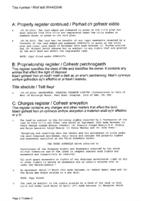
Boundary disputes are not resolved by the Land Registry, and it is usually too expensive to apply to the courts to resolve the dispute. The vast majority of boundary disputes are resolved by looking at the Land Registry documents for each of the adjoining properties, and to read the content, looking for helpful phrases, clauses and other clues. The documents to examine are the respective Title Registers, Title Plans and Associated Documents. The Deeds often have detailed Deed Plans attached to them. These are quite distinct from the Title Plan and have often been prepared for the express purpose of identifying the property boundaries at a date before Land Registration was contemplated.
All of these documents are provided in the Boundary Search. Where the documents are completely silent it may be necessary to have regard to Common Law boundary presumptions, which have arisen from the decisions of High Court cases relating to boundaries, and which establish a legal precedent that can be followed where there is no agreement to the contrary, i.e. where the documents with our search do not disagree.
In summary, then, Land Registry boundaries do not exist. The actual property boundaries must be gleaned from the Land Registry documents using a Boundary Search. Usually the information provided is sufficient to resolve most boundary disputes.
For more information please visit our detailed review of Boundary Searches.
Boundary Search 2 Properties
Obtain all the available property documents held to help resolve common boundary problems. For 2 Adjoining Properties.
£99.95Boundary Search 3 Properties
Obtain all the available property documents held to help resolve common boundary problems. For 3 Adjoining Properties.
£146.95Boundary Search 4 Properties
Obtain all the available property documents held to help resolve common boundary problems. For 4 Adjoining Properties.
£193.95


