The Title Plan
Contents
Overview
The Land Registry Title Plan is one of the main documents of Title, i.e. one of the main ownership documents, the others being the Title Register, and, if the property is leasehold, the Lease. The Title Plan is referred to in the Title Register as a means to support the property description, which id does visually, outlining the extent of the property owned by red edging.
Property Boundaries
The Title Plan provides boundary details in a general way only, i.e. lacking precision when looking closely at small areas, and for this reason it should only be used as a general guide whenever a boundary issue arises. This position is confirmed by the Land Registration Act 2002, section 60, which states that the boundary is shown in a general way unless it is Determined by the Land Registry. To have a boundary Determined an application must be made to the Land Registry, having first agreed the boundary position with your neighbour, and will only be granted if the Land Registry agree with your findings.
The reasoning behind the Title Plan being shown in a general way only is that the Plan’s red edging is copied onto an image of the property as shown on the Ordnance Survey Map. The red edging is plotted to the outside of the OS’s black edging. When the property is looked at closely it becomes apparent that the width of both the black and red inks have a thickness that may amount to inches or larger on the ground, and so most boundary disputes relate to small areas of land.
OS do not determine a property’s boundary. They carry out a survey and map the physical features on the ground as they are at the time of the survey. If there are no physical features they do not insert a boundary line. This is indicated on the Land Registry Title Plan who insert a dotted line to represent the general position of the boundary.
Easements and Restrictive Covenants
Easements and Restrictive Covenants are shown in the Title Plan by shading the relevant parcel of land in a colour, generally in accordance with the following colour conventions:
- Easements that benefit a property are shown in brown.
- Easements that burden a property are shown in light blue.
- Restrictive Covenants may be shown in pink or light blue.
- Rights of pre-emption are shown in yellow.
- Land removed from a Title is edged in green.
Title Registers describe easements and covenants verbally, and then refer to the Title Plan which shows them visually. Sometimes the Register also refers to a Plan attached to a Deed (a Deed Plan) which may contain additional useful information.
Scales
Title Plans are produced at the following scales:
| Urban Properties | 1:1250 |
| Rural Properties | 1:2500 |
| Remote Properties | 1:5000 |
| Very Remote | 1:10000 |
Measurements, Dimensions, Angles, T and H Marks
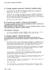
Title Plans do not as a general rule include measurements, dimensions, angles or T and H marks. Sometimes they do, but only rarely. Associated Documents, on the other hand, often have Deed Plans attached to them which do contain some or all of the above. The above image is an extract from a Deed Plan attached to a Conveyancing Deed. It contains boundary notes and measurements. It has been prepared independently of the Title Plan, most likely by a chartered surveyor.

Title Register
The Land Registry Title Register holds data relating to the property ownership, purchase price, mortgage, tenure, covenants, rights of way, leases and class of title.
£19.95Title Plan
The Title Plan shows an outline of the property and its immediate neighbourhood, and uses colours to identify rights of way, general boundaries and land affected by covenants.
£19.95Associated Documents
Deeds creating Restrictions, Covenants, Easements, etc. are often kept digitally by the Land Registry and made available for sale due to their invaluable detail and content to assist in further understanding the Restrictions, etc.
£29.95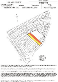

Links from this page
Help and Support
Information Hub Search
Was your question answered?
If you have any further questions regarding any of our products or services please feel free to contact us.
Land Registry Services are leading specialists in property data, conveyancing documents and environmental reports. Land Registry Services is neither owned or operated by the UK Government.