Private Lakes and Pond Ownerships
Key Information
Subject to contrary agreement, the bed of a lake or a pond belongs to the owner of the land surrounding it provided that the lake is totally enclosed by his land.
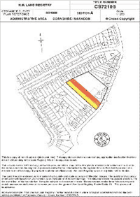
Therefore, if the lake you are searching the ownership of is within the curtilage of a house or other property, you need only to obtain a copy of the Title Register and look in section B for the ownership details. If you obtain the Title Plan as well this will show the lake within the red edging which outlines the property extent.
If the lake is abutted by different riparian, or lake-side owners, then ownership of the lake will extend to the mid-point of the lake for that part abutting your property. As ownership is in the lake bed, not the water in the lake, try to imagine the lake as being empty, when working out who owns it.
To obtain ownership details of a lake having several ownerships you should use our Map Search to identify the lake and to ascertain the division of ownerships. The Title Plans for the respective properties may outline in red edging that part of the lake within a respective ownership.
£69.95
Search Lakes and PondsFrequently Asked Questions
What does a riparian owner mean?
A Riparian owner is the owner of the riverbank or lakeside abutting a river or lake.
Do other people have the right to fish on the same stretch of riverbank as the owner of the Fishing Rights?
The owner of the land may reserve a right for himself to fish from that stretch of riverbank, but otherwise, no.
If I begin my search in satellite view can I change it to view in street view or map view?
Yes, you can change between views even while outlining your search area. This will not affect your outline in any way.
What is the difference between your Standard Map and your Advanced Map, and how am I to know which map to use?
Using our standard map allows you to zoom in on a property, e.g. a field, and drop a pin onto it. This is a simple and speedy exercise. The map is built into the application form and so we receive the data we need to proceed with your search, which will normally be carried out within an hour. This map works well with small properties such as small building plots and small fields.
The advanced map is for use with more complicated land areas. To use it you would first zoom into the property to be searched. When you click the page a pin is dropped, but this is the starting point of a line that you would then draw. You would click further along the search area and a straight line would be drawn between the two points, and you would carry on this way until completing the search area. This is useful for defining either a long, narrow tract of land, e.g. where you wanted to contact land owners along an area where pipes were to be laid, or for large elliptical or polygonal areas such as rectangular or triangular shaped areas.
The advanced map allows you to edit the lines you have drawn, by zooming in further and refining the positioning of the lines drawn.
The advanced map is very useful for large straight or polygonal areas of land, woodland, riverbanks, common land, and for sections of roads. We receive an exact copy of the map you have drawn and can readily identify each registered title of land within the search area.