Neighbourhood Searches
General Neighbourhood Information
Our environmental neighbourhood search provides details of local planning applications and land use and provides much useful information for people moving into the area.
In particular the report discusses the local housing market, the type of people living in the area, the main type of housing, average property prices, local educational facilities, council tax bands, local crime statistics, rights of way within 250 metres of the property, positioning of mobile phone masts, etc.
SelectFlood Risk
This report provides details of physical and water features within 250 metres of the property as provided by the Environment Agency, supported by detailed flood risk maps and summaries, and with further reports from the British Geological Survey and the Norwich Union.
SelectChancel Search
If a property is located withn the historical tithe boundary of a district or parish there may be a liability for chancel repair. Such may be the position where a property is near to a church or on land that was once in the ownership of certain universities.
SelectNetwork Rail
The Network Rail report provides information relating to buried rail services in the area surrounding the property and is supported by detailed maps. It includes data provided by GI Portal, Hazard Directory, Global Crossing and eBrowser. Features such as buried, surface and hanging cables, electrical switches, surface and buried troughing, steel trunking are included, with their locations.
SelectDrainage, Water and Cable Routes
Drainage, Sewerage and Water Report
The main function of this search is to provide a detailed plan of the routes taken by drains, sewers and waterworks near the property.
The map is very detailed and includes the type of drains, sewers and water pipes and a water quality failure report.
SelectElectricity Cable Routes Report
The search provides a detailed plan of the property area showing the cable routes and ducts, and the report provides details of easements, wayleaves and other rights that may have been granted in favour of the Electricity Board.
SelectBT Cable Routes Report
A detailed plan is provided by Openreach of the property area, detailing overground and underground BT plant, poles, manholes, joint boxes, BT boxes and distribution points. The report provides recommendations by Openreach for work to be carried out in the property area.
SelectCable & Wireless Equipment Report
Details of all cable and wireless equipment in the area of the property are provided, together with a detailed map showing their location.
SelectGas Pipeline Route Report
A copy of the Gas Mains Record Plan is provided with this search, plus the approximate location of all known gas mains, service pipes, valves, sypones and stub connections.
SelectMining
Coal Mining and Ground Stability Report
A coal mining search is generally carried out by persons about to move into the proximity of a coal mining area, or a former coal mining area. The search provides details of past, present and future coal mining, underground and above ground. Details of gas emissions, shafts, adits and surface geology are provided and also past subsidence.
The report also covers ground stability.
SelectLimestone Mining Report
The Limestone Mining Report is obtained when moving into a limestone area to ascertain if there is risk of subsidence from limestone workings or mines. To obtain this report a Land Registry Title Plan must be submitted, and the Report includes the cost of this.
SelectGypsum Mining Report
A gypsum mining report is obtained when moving into an area affected by gypsum mining. The search will reveal any gypsum mines or workings within the proximity of the property, and provide details of the depth of any workings. Information relating to the granting of planning consents is also provided.
SelectContamination
Radon Search
Radon is a radioactive gas that occurs naturally in some areas of England. Over time it decays into other substances, which increases the risk of exposure to radiation. Exposure to radon gas is associated with an increased risk of lung cancer.
The report provides measurements and statistics for affected areas near to the property, and includes an estimate of the likelihood of increased levels of radon existing in the property itself.
SelectContaminated Land Report
The Land Contamination Report includes an informed opinion as to the safety of the propety and the area surrounding it in so far as it may be affected by contaminated waste or other materials. All data provided is supported by detailed maps of the area with emphasis on landfill sites, waste, pollution control, radioactive and hazardous materials, dangerous substances, control of major accident hazards, discharges and emmissions.
Select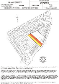
By using DeedFlow, you will be able to quickly obtain official copies of Land Registry Title Registers and Title Plans, Leases and Deeds, as well as many other conveyancing searches and environmental reports.